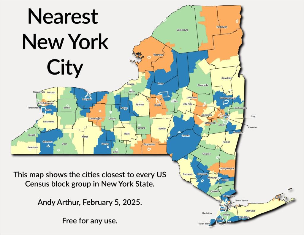
Thematic Map: Nearest New York City Download a High Resolution JPEG Image of the Nearest New York City or an Adobe Acrobat Printable PDF of the Thematic Nearest New York City. About Nearest New York City .... Heading to the city? Here is the closest city to every Census Block Group in New York State as measured by st_nearest. More about Urban Life...Aerial PhotosSOOKE HISTORY: Bedspring Bridge was unforgettable experience | Sooke News MirrorThe Eagle Lake & West Branch Railroad: Discover History & Explore Nature: State Parks and Public Lands: Maine ACFMaps and InteractivesUS Roads and Railroads, Rand McNally 1918Traffic Light 🚦 Caution ⚠ FlashersThe suburbs of GreeceThe Log Homes of Albany CountyThe Eagle Lake and West Branch RailroadStudebakerSouthern Albany County – Bridge InventorySmoke from Canadian Wildfires Reaches EuropeSalk InstituteRailroad Mileage Map 1910 – Rand McNally and CompanyNY Correctional FacilitiesNY 8 and 12 Intersection at Interstate 790 and the ThruwayNigger Hill in PrattsvilleMODIS Terra – June 7, 2023 – Wildfire Smoke Blankets the NortheastMODIS Terra – June 6, 2023 – Air PollutionMODIS Terra – June 29 and June 30, 2023MODIS Aqua – June 6, 2023 AfternoonMilletown Plaza ParcelLocation of the Palatine Ohio Trail DerailmentLarge junkyard south of ScrantonHow Fast Can I Drive on State Highways in Capital Region ?Houses Heated Primarily with Wood in Southern Albany CountyHartford Ghost RampsCovered Bridges in New York StateClayton, NY – One of New York’s Two New Urban areas... photos, maps and other content from from Urban Life. Leave a Reply Cancel replyYour email address will not be published. Required fields are marked *Comment * Name * Email * Website Save my name, email, and website in this browser for the next time I comment. Δ
More about Urban Life...Aerial PhotosSOOKE HISTORY: Bedspring Bridge was unforgettable experience | Sooke News MirrorThe Eagle Lake & West Branch Railroad: Discover History & Explore Nature: State Parks and Public Lands: Maine ACFMaps and InteractivesUS Roads and Railroads, Rand McNally 1918Traffic Light 🚦 Caution ⚠ FlashersThe suburbs of GreeceThe Log Homes of Albany CountyThe Eagle Lake and West Branch RailroadStudebakerSouthern Albany County – Bridge InventorySmoke from Canadian Wildfires Reaches EuropeSalk InstituteRailroad Mileage Map 1910 – Rand McNally and CompanyNY Correctional FacilitiesNY 8 and 12 Intersection at Interstate 790 and the ThruwayNigger Hill in PrattsvilleMODIS Terra – June 7, 2023 – Wildfire Smoke Blankets the NortheastMODIS Terra – June 6, 2023 – Air PollutionMODIS Terra – June 29 and June 30, 2023MODIS Aqua – June 6, 2023 AfternoonMilletown Plaza ParcelLocation of the Palatine Ohio Trail DerailmentLarge junkyard south of ScrantonHow Fast Can I Drive on State Highways in Capital Region ?Houses Heated Primarily with Wood in Southern Albany CountyHartford Ghost RampsCovered Bridges in New York StateClayton, NY – One of New York’s Two New Urban areas... photos, maps and other content from from Urban Life.
Leave a Reply Cancel replyYour email address will not be published. Required fields are marked *Comment * Name * Email * Website Save my name, email, and website in this browser for the next time I comment. Δ