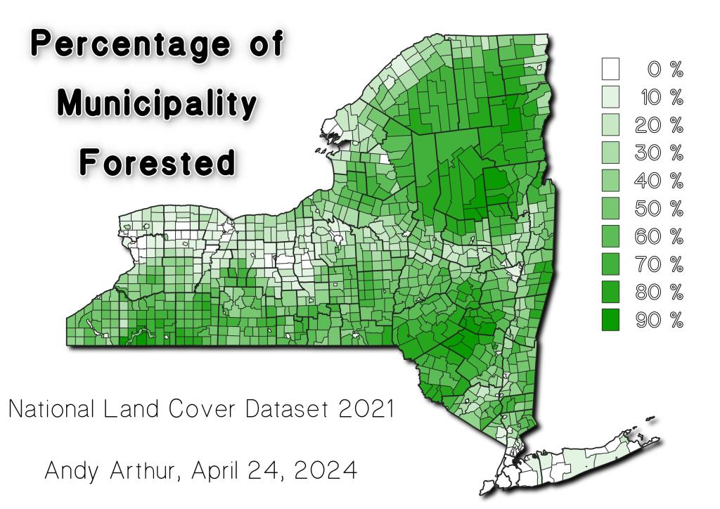
Thematic Map: Percentage of Municipality Forested Download a High Resolution JPEG Image of the Percentage of Municipality Forested or an Adobe Acrobat Printable PDF of the Thematic Percentage of Municipality Forested. More about The Woods...Maps and InteractivesSlate Run Road / Gamble Run Road CampsitesNational Forests in Minnesota, Wisconsin and MichiganInland Trout Stream FishingCow Hell SwampAllegheny National Forest Deer Density IndexPlaces I Camped in 2022Places I Camped in 2020NYS Wildlife Management Areas2019 Buck Harvest by TownPercentage of Municipality ForestedPlaces I Camped in 2021St Lawerence County Primative Campsites And Lean Tos... photos, maps and other content from from The Woods. Leave a Reply Cancel replyYour email address will not be published. Required fields are marked *Comment * Name * Email * Website Save my name, email, and website in this browser for the next time I comment. Δ
More about The Woods...Maps and InteractivesSlate Run Road / Gamble Run Road CampsitesNational Forests in Minnesota, Wisconsin and MichiganInland Trout Stream FishingCow Hell SwampAllegheny National Forest Deer Density IndexPlaces I Camped in 2022Places I Camped in 2020NYS Wildlife Management Areas2019 Buck Harvest by TownPercentage of Municipality ForestedPlaces I Camped in 2021St Lawerence County Primative Campsites And Lean Tos... photos, maps and other content from from The Woods.
Leave a Reply Cancel replyYour email address will not be published. Required fields are marked *Comment * Name * Email * Website Save my name, email, and website in this browser for the next time I comment. Δ